Introduction
There is no single document that identifies property boundaries and so this chapter provides samples of various ways to identify the boundary positions using the documents provided by this search, which are the only registered documents that are available to identify them.
Property Address
The A section of the Title Register describes the address by reference to the Plan. This is particularly useful where the property does not have a full postal address. In such cases the Title Register and Title Plan must be examined.

Amendments to the Title Plan
The Title Plan is sometimes updated, and this will be referred to in the A section of the Register. The sample above is a further extract from the A section of the Title Register referred to earlier. The area in red edging has been extended from what it previously was. This entry clarifies that the present Title Plan shows the extended plan.

Description in a Deed
Often, an old Deed will contain a description of the property address. In the sample below there are measurements of the land, together with OS references.

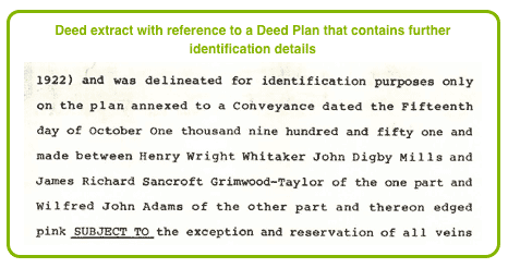
Reference to a Deed Plan
The following conveyance extract continues its property description by referring to a Deed Plan that is attached to another conveyance. Sufficient details of that conveyance are provided to obtain a copy.

Party Wall Declaration
The following extract from a transfer deed refers to one of the walls of the property, declaring it to be a Party Wall, and states that it shall be maintained at the joint expense of the owners on each side of it.

The following extract from a title register expressly states that the walls and fences that are are not party walls and fences are maintainable by the owner of that property. This is supported by a deed plan which has been filed and would therefore be provided with our Boundary search.

Implied Boundaries
In the following Title Register extract found in the C section the owner has the right to enter adjoining property in connection with drains and sewers. The part of the adjoining property marked in brown and yellow on a Deed Plan, which is referred at the end of the paragraph, belongs to the adjoining land. The said sewers and drains are on the adjoining land and the border must fall short of them.

The Deed Plan will almost certainly contain more detail of the boundary positions.
Boundary Provisions
The A and C sections of the Title Register will sometimes contain provisions as to boundary structures. The provisions will benefit the property. In the following extract of a Title Register reference is made to the deed containing the provisions and states that a copy of it has been filed, which means that it would be provided with our Boundary Search. This Deed would make an important contribution to the determination of boundary rights between the adjoining owners.

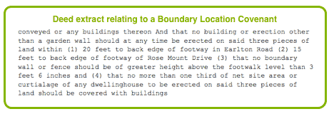
Boundary Location Covenant
Because of the wording of this covenant that has been cited in a Title Register there is a clear implication that any such boundary wall or building that is built lies further out than 20 feet from the back edge of the footway in Earlston Road, and further out than 15 feet of the back edge of a footway on Rose Mount Drive.

This Deed is referred to in the Title Register, which states that a copy of it has been filed. In such cases a copy of the Deed will be provided with our Boundary Search.
Points Between A and B
The following extract from the B section of a title register lists a personal covenant that affects only the current owner. It does not run with the land and will not affect a subsequent purchaser unless he enters into a similar covenant. The purchaser has covenanted to erect a fence between points marked A and B on a deed plan, a copy of which has been filed by the Land Registry and which would form part of our Boundary Search.

Boundary Presumptions
Common Law Boundary Presumptions arise from decisions of cases heard in the higher courts (e.g. Court of Appeal and House of Lords). These presumptions can only apply in the absence of contrary agreement and where no an Act of Parliament supersedes that presumption. Therefore it is very important to look at any documents that may constitute a contrary agreement before attempting to apply a Legal Boundary Presumption.
If there is a Contrary Agreement it will almost certainly be evidenced in the property's title documents. These are the documents that we supply to you as part of our Boundary Search.
Section 2 provides full details of the current Boundary Presumptions.
Land Added to the Title
Land purchased after the main property purchased may be added to the Title, in which case its property extent also needs to be taken into account.

Land Removed from the Title
Land may also be removed from a Title, as where part of the land is sold off separately. In such a case a separate Title is created for the land removed. The Title Plan for the land remaining will show the boundaries of the land removed edged in green, as shown in the example below.

Deed of Rectification
The extent of the land owned may be amended via a Deed of Rectification. Where this occurs a copy of the Deed will be available as a scanned Deed and thus be part of our Boundary Search (unless filed under a separate Title). The Deed will also have annexed to it a Deed Plan, using coloured markings to identify the amended extent of the property. The coloured markings will match the description provided in the Title Register.

T and H Marks
T and H marks on a Plan will indicate ownership or maintenance liabilities for a boundary. The side of the boundary upon which the bar of the T lies will indicate this. Where an H is shown this means that ownership or maintenance of the boundary is shared.
T and H marks rarely appear on a Title Register, but will appear on a Deed Plan. Where a Deed Plan is referred to in the Title Register but fails to show the T or H marks there will usually be a note in the C section of the Register to state as much.